
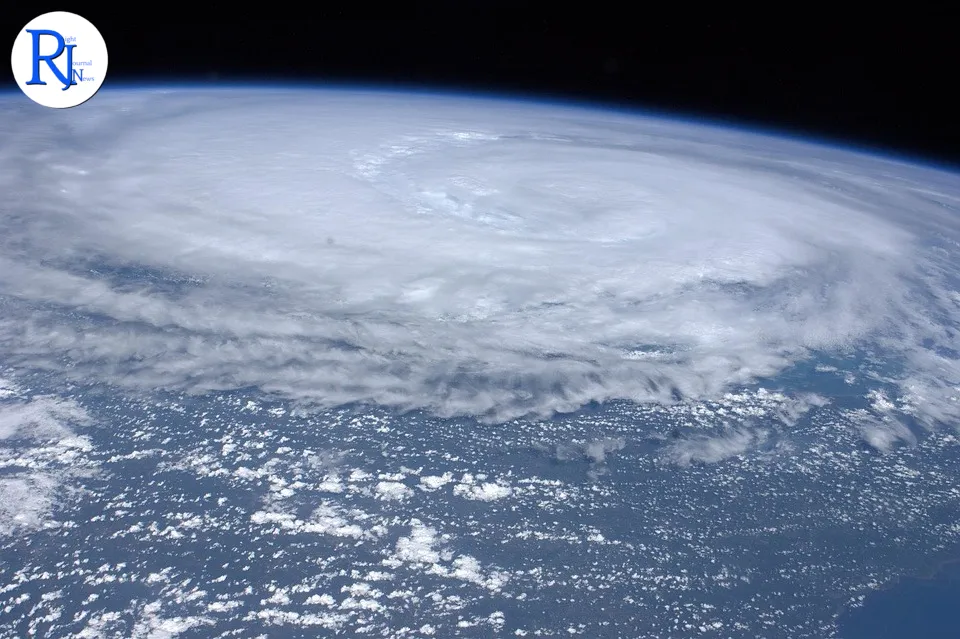
Hurricane Melissa intensified into a Category 5 storm with sustained winds of about 160 mph (257 km/h) and moved towards Jamaica on Tuesday, prompting urgent warnings from officials and emergency agencies. Authorities urged people in low?lying and coastal areas to get to higher ground and make use of shelters. They warned of “multiple life?threatening hazards,” including destructive winds, storm surge, flash flooding and landslides. Forecasters tracking the storm said Melissa gained strength rapidly over warm Caribbean waters after a swift burst of intensification over the weekend. Communities across Jamaica prepared for high winds, intense rain and coastal inundation as the storm approached landfall.
Melissa began as a cluster of thunderstorms off West Africa before travelling west across the Atlantic. It reached tropical storm status north of Venezuela about a week ago, then strengthened through the Caribbean Sea. On Monday morning it reached the top of the Saffir–Simpson scale, the measure used by meteorologists for hurricane wind categories. Officials told residents to charge phones, secure property, clear drains, stock essential supplies and stay tuned to official alerts, saying the next 24 to 48 hours would be critical for safety.
Context and timing
The storm’s rapid intensification over the weekend lifted Melissa from Category 4 to Category 5 as it tracked west through the Caribbean Sea. By Monday morning, it produced sustained winds near 160 mph (257 km/h), according to meteorologists monitoring the system. On Tuesday, Jamaican officials issued strong guidance to move to higher ground and use shelters as the eye moved closer to the island. Emergency teams positioned resources ahead of the worst conditions, with coastal and flood?prone communities urged to take action before winds strengthened further.
Officials warn of ‘multiple life?threatening hazards’
Government agencies urged people to act without delay as Melissa closed in. They called on residents to relocate from flood zones and unstable hillsides, and to go to established shelters or stay with family and friends in safer locations. Advisories highlighted the risk of “multiple life?threatening hazards”, a phrase officials used to stress the seriousness of the threat. The guidance followed standard hurricane safety protocols for Jamaica, where heavy rain can trigger sudden floods in valleys, while strong winds can damage roofs and power lines.
Emergency managers also highlighted storm surge dangers along exposed coasts. Surge pushes seawater inland and can lift tides by several feet, depending on the storm’s strength and angle of approach. Surge often causes the deadliest impacts in strong hurricanes because it arrives quickly and can trap people in homes or vehicles. Authorities urged drivers to avoid flooded roads and reminded residents that even shallow, fast?moving water can sweep people away. They asked the public to keep roads clear for emergency vehicles and to report hazards through official channels.
How Hurricane Melissa intensified so quickly
Melissa formed as a disturbance off West Africa, a common birthplace for powerful Atlantic storms during late hurricane season. After organising over several days, it became a tropical depression and then a named tropical storm north of Venezuela about a week ago. Warm sea surface temperatures and favourable atmospheric conditions helped it strengthen. Over the weekend, Melissa underwent rapid intensification, a process in which wind speeds increase by at least 35 mph (56 km/h) within 24 hours. Meteorologists say rapid intensification happens more often when waters are very warm and wind shear is low.
By Monday morning, Melissa reached Category 5 status on the Saffir–Simpson scale, with sustained winds near 160 mph (257 km/h). Category 5 is the highest level on the scale and signals the potential for catastrophic wind damage. Forecasters said the storm’s compact core and well?defined eyewall supported its peak strength. They noted that small wobbles in track can shift the most severe conditions, but the overall threat to Jamaica remained high. They urged people to treat the forecast cone as guidance and not to focus solely on the central line of the track.
What Jamaica can expect: wind, rain and storm surge
Category 5 winds can tear off roofs, down large trees and bring down power lines. Flying debris can pose extreme danger. Even well?built structures can suffer severe damage near the core of strongest winds. As Melissa approaches, outer rainbands can produce squalls that build in intensity. These squalls can trigger flash floods in minutes, especially in urban areas and steep valleys. Jamaica’s terrain increases the risk of landslides when soils become saturated, particularly in hillside communities and along cut slopes.
Coastal communities face storm surge and large, battering waves. Surge depends on wind strength, pressure, coastline shape and the timing of local tide. Low?lying areas on the windward side of the island face the highest risk of inundation. Officials advised residents to move belongings to higher floors, disconnect electricity in flooded rooms and avoid contact with floodwater, which can carry contaminants and hide hazards. They asked fishers and boat owners to secure vessels and leave the water well before conditions deteriorate.
Preparedness on the island: shelters, power and transport
Authorities urged residents to use shelters if their homes cannot withstand strong winds or are in areas known to flood. They encouraged people to bring identification, medications, essential documents, bedding, food, water and supplies. Families were told to plan for communications in case mobile networks become strained, and to share evacuation plans with relatives. People with special medical needs received guidance to arrange backup power for devices and to alert local support services where available.
Power and transport networks face a high risk of disruption during a major hurricane. Strong winds can damage overhead lines and block roads with trees and debris. Heavy rain can wash out bridges and isolate communities. Officials asked the public to keep vehicles fuelled and to limit travel during peak conditions. Airports and ports can experience delays when winds rise, and airlines and shipping lines often adjust schedules for safety. People with travel plans were told to follow service updates and to prioritise personal safety over itineraries.
Tracking the storm and staying informed
Meteorologists continued to monitor Melissa’s structure, wind field and central pressure as it moved closer to Jamaica. Forecasters use satellite imagery, radar and aircraft reconnaissance when available to refine intensity and track estimates. Even small shifts in track can change which areas see the worst winds and surge. Officials therefore urged everyone across the island to prepare, not only those near the projected centre. They reminded the public that hazards extend far from the eye, with dangerous conditions spreading across wide areas.
Residents were urged to follow updates from recognised authorities and to treat social media rumours with caution. Clear, trusted information helps people act early and avoid unnecessary risk. Households were told to maintain a battery?powered radio, charge devices and conserve power when needed. Emergency teams asked communities to check in on older people, people with disabilities and neighbours living alone, and to keep emergency numbers at hand. They also asked people to stay indoors when conditions worsen and to avoid venturing out during the eye, which can bring a sudden and deceptive lull.
Climate signals and extreme hurricane behaviour
Scientists have studied an increase in rapid intensification events in recent decades. Warmer sea surface temperatures add energy to storms, which can fuel fast jumps in strength when other conditions align. While each hurricane is different, research shows that a hotter ocean raises the ceiling for potential intensity. Experts emphasise that preparedness and early action remain the most effective ways to reduce risk from extreme weather. They point to building standards, land?use planning and strong emergency systems as key defences against wind, surge and flood.
Jamaica has long experience with severe tropical cyclones, and communities have learned lessons from past storms. Those lessons include the value of early evacuation from flood zones, the need to secure roofs and the importance of protecting water sources from contamination. Officials repeated those messages as Melissa closed in. They said people should focus on life safety first, as property can be repaired but lives cannot be replaced.
Wrap?up
As Hurricane Melissa bears down with Category 5 force, Jamaica faces a period of intense winds, heavy rain and dangerous coastal surge. Officials have urged people in at?risk areas to move to higher ground or into shelters and to follow trusted guidance. The storm’s rapid intensification underscores how quickly conditions can change in the Caribbean, especially over very warm seas. Prepared households and communities will navigate the coming hours more safely, with clear plans and strong networks of support. Forecasters will refine the track and intensity as new data comes in, but the core message remains the same: act now, stay informed and prioritise safety until the storm passes and authorities give the all?clear.